


A web-based tool for mapping invasive species using local expertise
 Invasive, Planning, Technology-GIS
 Internet savvy researchers from Princeton and the University of Michigan have created a web based tool to integrate local expertise about invasive species occurance into regional-scale maps. Understanding invasive species distribution and abundance is critical for successful control efforts. While local experts often have this information for the immediate area, maps at the county and state level are rare and when they exist they tend to be incomplete and/or very rough in detail. This in turn creates a lack of a big picture, which impedes coordinating control efforts, planning, monitoring, and research.
In order to demonstrate the tool’s effectiveness, the research team performed a trial run across the southeastern United States, inspecting three of the region’s most noxious invasive plant species: (1) Chinese/European privet, (2) kudzu, and (3) cogongrass.
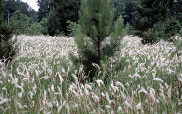 Infestation of cogongrass in pine reforestation. Image credit, Charles Bryson, USDA Agricultural Research Service.Mapping tool methodology
The mapping tool provides a grid, in Google Map format, for the prescribed area. Each square (quarterquad) measures 6 km x 6 km (about 3,600 hectares), a much finer scale compared to the typical county or state invasive species map. For each quartersquare the researchers sought out invasive plant managers and academics as participating experts (contacted via email). Experts found their designated area using the Google Map tool, zoomed in to the specific quarterquad, clicked the marker within, and chose the appropriate percent cover for each species. After doing so, the data was automatically saved in the database and subsequently visually presented on the map itself.
Study Results
After only six months, and with over 180 participating experts, a regional map was created that portrays invasive species cover over Alabama, Arkansas, North Carolina, and Tennessee. Invasive species presence and abundance data has never been collected, synthesized, and displayed as a regional map across this vast of a region before.
The tool’s fine scale appears to allow for more precise projections than other methods used in the past. For example, compared to the most recent county scale map for Alabama, which displayed privet dominance over 100% of the state, this study found that in one third of the state it made up less than 1% cover.
To confirm the system’s accuracy, all data were crosschecked with an existing U.S. Forest Service dataset and individual point data that has been collected at various local sites. They also checked for internal consistency. Multiple experts entered data on the same quarterquad - those containing large differences were considered “outliers” and completely removed. Both methods found a fairly high level of reliability for the web tools.
Implications for conservation
This tool has the potential to bridge the gap between the current, loose network of experts and managers dealing with invasive species. It offers a much-needed “big picture” scenario for future management, which can help with planning and coordinating control efforts. This can also help managers more clearly communicate the extent of the problem to help build public and political support and secure needed funding.
--Reviewed by Evyan Borgnis
| Source: | Natural Areas Journal |
| Title: | A novel web-based, ecosystem mapping tool using expert opinion |
| Authors: | a, David Marvin, b) Bethany Bradley and b) David Wilcove |
|
a) University of Michigan, Ann Arbor, Michigan |
Reader Comments